

I can’t say as ever I was lost, but I was bewildered once for three days. —Daniel Boone
“A New Sky and a Strange Earth.” by Ginny Tschanz
Kentucky, in early 1775, was the most dangerous area in America. As the European settlers pushed westward from the thirteen colonies, they ran into fierce resistance from Indian tribes whose hunting grounds were being invaded by the white man.
The famous woodsman, Col. Daniel Boone, and John Farrar, the son of a plantation owner, travelled from North Carolina to the site where they would build a fort on the Kentucky River. They road horseback, or sometimes walked, protecting their horses who struggled through icy streams, downed timber, thick cane fields, and deep ravines. Their prized dogs, Hector, Hunter, and Chester, alerted them to dangers. A donkey named Clyde aggravated them, but carried essential baggage the horses couldn’t handle. It took three weeks to cover 250 miles over the Eastern seaboard terrain.
Boone was guide and Farrar was the gunman protecting their party from Shawnee, Chickamauga, and Muscogee warriors. After they reached their first destination on the Watauga River of Tennessee, Farrar would represent the Cherokees as transfer agent for some twenty million acres of land bought by Judge Richard Henderson’s Transylvania Company.
Henderson succeeded in the purchase only because the tribes living on the edges of the fertile Bluegrass couldn’t protect their “Dark and Bloody Ground,” from rivals. The tribes had shared Kentucky as a common hunting ground for centuries.
The Cherokee chief, AttaKullaKulla, who spoke passable English, had been a young delegate to the English Court of St. James in 1730. He would now negotiate the land sale with Henderson for the sum of £10,000 pounds sterling. His niece, Nancy Ward, was the daughter of ‘Tame Doe’ and British officer Francis Ward. As a “Beloved Woman,” she was the hostess for her uncle during long, formal talks and was the equal of men, fighting alongside warriors and speaking in tribal councils.
Before a treaty was completed on March 20,1775, Henderson had already sent Boone and Farrar out to mark and clear a Wilderness Road into the interior of Kentucky. The two men left with a party of thirty-five axemen to clear a wide road for supply wagons to reach Martin’s Station near Cumberland Gap, the preferred pass through the Appalachian Mountains.
At their final destination in Kentucky, Boone and Farrar planted corn, hunted wild game, and built a stockade which enclosed log cabins and a fort. The roofs of the log cabins slanted inward to make it easier to douse fires started by flaming arrows during enemy attacks. A buried magazine stored gun powder. Cattle could be brought within the stockade walls at night. Protection was essential and although everyone worked long hours to survive, few made it on the frontier.
Meanwhile a letter announced that fighting had started in 1775 at Bunker Hill, with patriots eager to declare independence from the British. It was time for patriots to rally! But Farrar couldn’t leave Kentucky until his agreement with Judge Henderson ended in 1776.
The Boonesborough settlers endured the coldest winter of the century in 1779-1780 when the Chesapeake Bay froze over and wild birds fell frozen from the sky. They were under siege from enemies, claimed tracts of rich land, and made salt at “licks” to preserve their wild game. The last major battle of the Revolution was at Blue Licks where the patriots were defeated and Boone was temporarily disgraced.
When the Revolutionary fighting ended in 1781, Captain John Farrar returned to his father’s plantation and married Elizabeth Abernathy, the daughter of a member of the North Carolina General Assembly. The couple raised ten children and lived in Lincoln County, North Carolina. If a reader questions how a county could have been named after Abe Lincoln, who presided during the Civil War, there is an explanation; the county was named after Lt. Col Benjamin Lincoln, an officer in the Revolution.
After Elizabeth’s death in 1803, Farrar married Elizabeth Williams, and moved to his newly settled “Boone’s Hill” farm in Tennessee, where he fathered another nine children. He named nineteen living children in his last will of 1826, despite not having married until he was 33 years old. Early settlers prized children as workers for the endless tasks of raising food, making clothing, and protecting their land. There were few opportunities to see neighbors, but children were schooled at home or by tutors if the family could afford them. Christian moral formation was essential, and done mainly at home or by fiery circuit riders who left no doubt about the reality of heaven and hell.
The last meeting between Farrar and Boone was before Boone’s 1820 death when Farrar journeyed to Missouri to petition the government on behalf of clearing title to Boone’s land claims. Never careful with records, Boone eventually lost his land claims and died impoverished at the age of 86.
“A New Sky and Strange Earth” is an adventure story suitable for all ages. Available in all formats.
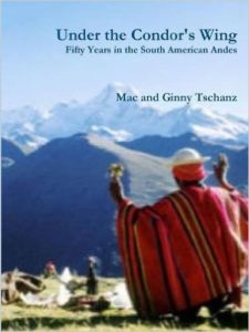 “Under the Condor’s Wing: Fifty Years in the South American Andes”
by Mac & Ginny Tschanz © 2011, 280 pp, with illustrations.
We are Ginny and Mac Tschanz, an American couple who for nine years lived a grand adventure in the Andes Mountains of South America, while Mac, a U.S.G.S. Geologist, helped develop the economic promise of an area rich in natural resources. This web was developed by our granddaughter, Rachel, to publicize our 280 page book along with Ginny’s poems and prose, her watercolors, and our children’s daring ventures in mountaineering, trekking the length of the continent, and ministering to orphans in Costa Rica. So try to explore as much of this web as time allows. You’ll not be disappointed if you’re one of those rare birds who love both adventure and art in equal measure.
From 1960 to 1965 Mac’s first geological assignment was to help develop a National Department of Geology in Bolivia, where the capital of La Paz sat in a canyon at 11,975 ft. Surrounded by mountains rising above 22,000 ft. Although we suffered physical hardships amid political instability in a nation under an almost constant state of siege, we nevertheless remembered our years in Bolivia as fulfilling and happy.
After four and a half years in Bolivia, we were transferred to Colombia, where Mac mapped in the world’s highest coastal range, the Sierra Nevada de Santa Marta (18,701 ft). This proved to be a stressful time of long separations amid an atmosphere of political distrust and violence. We lived first in the hot, humid tropics on the Caribbean coast and later in the cool central highlands.
Fast forward to 1991 when our oldest son, Tor, and his wife Dawn trekked the length of South America on a trip which lasted nine months and covered over 3,500 miles. Tor and Dawn were kindred spirits who traveled with the reasoned assurance of two professional engineers. Being without pretensions, they were as much at home crawling down a mine shaft in Potosí, Bolivia, as cruising on a yacht in the Galapagos.
In 2000 our second son, Michael, traversed the Inca Trail and scaled El Huascarán (22,204 ft.), the highest peak in Peru. In a second trip in 2007 he bicycled across the Andes, descended the 13,648 foot Colca Canyon, and scaled Mount Ampato (20,630 ft). Michael’s summit of two of the highest Andean peaks with scant acclimation to the altitude and minimal mountaineering experience attested to his remarkable athletic skill.
Finally, our granddaughter Meghan, a University of Colorado student, spent the summers of 2009 and 2010 on a Costa Rican mission sponsored by Boulder Presbyterian Church. She served with distinction during two summers in the field. Other missions before her 23rd birthday were in Thailand, Australia, and Papua New Guinea.
In addition to Spanish descendants, the Aymará and Quechua Indians comprised the largest population group. They lived as they have for centuries retaining their native customs and languages. Few learned Spanish and they are very poor.
Being a mountain family, we took to the Andes with enthusiasm. Our ancestors lived in the Swiss Alps and the Colorado Rockies are home to all three Tschanz generations.
The title alludes to the magnificent condors which soar over the snow capped Andean peaks. With a wing span of up to 10 feet, they are a dramatic symbol of a beautiful and perilous continent. Ginny Tschanz November, 2011
Would love to be kept apprised of the publication of the Farrar book. Thank you.